Follow Us on Google
By Chukwuma Umeorah
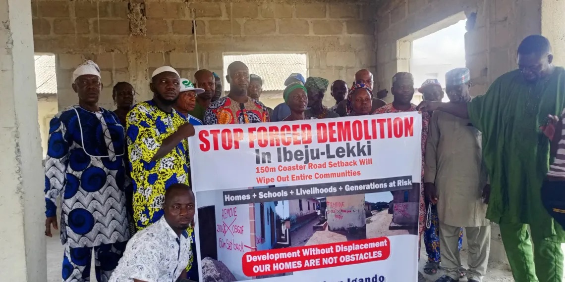
Community leaders in Ibeju-Lekki Local Government Area of Lagos State have raised the alarm over fresh markings linked to a proposed 150-metre setback along both sides of the Lagos-Calabar Coastal Highway, warning that the development could trigger new demolitions and displace long-established coastal settlements.
The markings were allegedly carried out by officials from the Office of the Surveyor-General of the Federation (OSGOF), with about 53 communities said to be affected, including Eleko, Badore, Okun-Igando and others.
While expressing support for the coastal highway project, the leaders appealed to President Bola Tinubu and the Lagos State Government to suspend any further demolition and grant waivers for existing settlements, stressing the need for consultation and clarity on the project’s alignment and setback provisions.
Speaking for the communities, Chief Adebayo Agbabiaka said residents observed officials marking buildings within what they described as a 150-metre corridor on both sides of the road. “Initially, when they were constructing the road, they demolished several properties leaving many of us displaced. After all our sacrifices, homes, shrines, heritage sites, some people came again to mark houses for demolition. They said they were from the Surveyor-General’s office. If they take 150 metres to the right and 150 metres to the left, nothing will be left of our community,” he said.
Agbabiaka noted that many of the affected structures were built decades ago, with materials transported by waterways from Epe and manually conveyed into the settlements, reflecting the long history of habitation in the area.
He added that repeated realignments of the coastal road corridor had already led to the demolition of houses, storey buildings and cultural sites across parts of the Ibeju-Lekki axis.
Residents also criticised compensation from previous demolition exercises, describing it as inadequate in view of current land values in the area.
According to Agbabiaka, some families received between N9 million and N10 million, which he said could not secure land in Ibeju-Lekki or support the relocation of entire households. He further alleged that compensation in some instances covered crops but excluded buildings, leaving several homeowners without payment for demolished structures.
Agbabiaka warned that enforcing another setback could heighten tension among residents who had already lost homes and heritage sites to the project. “The 150 metres they want to take again will erase the community. It is our communal land. We appeal to the government to grant us a waiver; we will be very grateful,” he said.
Other News
Another community member, Prince Abraham, expressed concern over claims that a wider corridor could be enforced in the future, noting that such a move could further threaten the existence of the settlements.
The Baale of Eleko Community, Gbadebo Fatau, maintained that the communities were not opposed to the highway project but called for dialogue and fairness in its implementation. “We support the coastal road. It is a legacy project of President Bola Tinubu, but development should not erase entire communities without dialogue and justice. We appeal to President Tinubu to put a human face to our plight and let us remain in our ancestral land.”
When Sunday Sun reached out to the Federal Ministry of Works, the Federal Controller (Lagos), Olufemi Dare, said the fresh markings were not carried out by the ministry.
“Those markings are not from the Federal Ministry of Works, they are from the Office of the Surveyor-General of the Federation. We have built our road, the road has passed and so it is not from us. The Office of the Surveyor-General is in the best position to explain what is going on,” he said.
Another source within the Ministry, who spoke on condition of anonymity, told our correspondent that the recent markings were meant to differentiate federal land rather than serve as demolition notices.
The source said the exercise was intended “to let the communities be aware that the marked buildings, 150 metres to the right and 150 metres to the left, are sitting on Federal Government land.”
However, the source did not clarify the practical implications of notifying residents that their properties fall within federal land.
A visit to the affected area by our correspondent showed that several structures bore inscriptions reading “Remove, 150-metre setback, OSGOF,” dated January 27, 2026.
When contacted, the Zonal Director of Survey Coordination of the Office of the Surveyor-General of the Federation in Lagos, Sunday Adefarati, declined to comment, saying, “I am not authorised to speak for our organisation or provide details of the markings.” He added that inquiries should be directed to the head office in Abuja.
The Lagos-Calabar Coastal Highway, a Federal Government infrastructure project expected to span about 700 kilometres from Lagos to Calabar, is designed to traverse several coastal states and remains one of the major ongoing road projects under development.